

In a historic step for weather forecasting in India, the Coastal Atmospheric Research Testbed (C-ART) open-field observatory was commissioned today at Andhra University (AU) in Visakhapatnam. Headed by Dr M. Ravichandran, Secretary, Ministry of Earth Sciences (MoES), it is an IITM project under the Mission Mausam. This initiative could deliver more precise cyclone warnings and monsoon information, something vital in a climate change scenario.
ALSO READ- Finland Launches Europe’s First Lithium Project
Ceremony Highlights: A Star-Studded Launch-
AU campus was the site of the event, which saw some of the most important personnel from global institutions, namely AU Vice-Chancellor Prof. G. P. Raja Sekhar, IITM Director Dr A Suryachandra Rao and Prof. CV Naidu, Head of Meteorology & Oceanography, etc.
- Welcome Address: He highlighted IITM legacy and AU department C-ART, Phase 1 infrastructure, whetting the appetite for sophisticated tools, meanwhile reiterating the need for academia–research partnership to bolster climate science activities.
- Brochure & Film Release: Dr Ravichandran presented a comprehensive brochure on C-ART objectives and then a short film on the role of Visakhapatnam. There was a brief mention of how Visakhapatnam is important to the world for weather monitoring and research progress.
- Inaugural Speech: VC Prof. Raja Sekhar praised AU-IIITM synergy as a “scientific milestone” for longitudinal relationships. He underlined the importance of such collaborations to promote future-breaking scientific instrument construction.
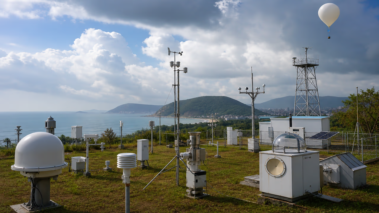
- Balloon Launch: Local dignitaries released a meteorological balloon and obtained the initial data collected from a thunderstorm, a mere demonstration of real-time capabilities. This presentation demonstrates the utilisation of specialised instruments in advanced real-time.
Dr Ravichandran noted the MoES Mission Mausam push for dense observation networks, calling for university partnerships in severe weather tracking.
What is Coastal Atmospheric Research Testbed (C-ART)?
C-ART is the product of IITM, an open-field node on AU land for watching border coast atmospherics all day. The eastern corner of Visakhapatnam is the perfect place to study all that is happening in the Bay of Bengal, from depression to rain murk.
Core Goals:
- High-res diagnostics of monsoon convection and rain microphysics
- Refining NWP models through improved parameterisation.
- Data assimilation for forecast upgrades; national facility for researchers.
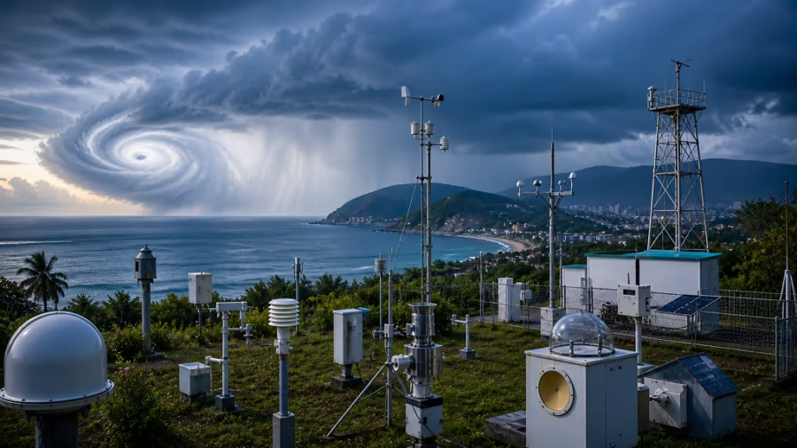
A growing number of climate extremes, like super cyclones in 2025, will only boost the utility of this testbed. It is already making early warning systems stronger and reducing disaster risk to coastal nations.
Did You Know? The C-ART instruments unlock the shape/size of a raindrop, which will be crucial for understanding the formation of precipitation and the path of the cyclone.
Current Instruments: Powering First Observations-
Phase 1 is live, capturing today’s thundershower data. Here’s the lineup:
Installed Tech Arsenal:
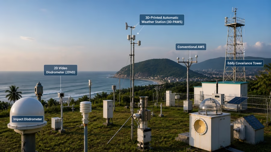
- Impact Disdrometer & 2D Video Disdrometer (2DVD): Track drop sizes, shapes, rain microphysics. They aid in better understanding rainfall intensity and distribution. This data assists in the modelling of weather prediction and hydrological processes.
- 3D-Printed Automatic Weather Station (3D-PAWS) & Conventional AWS: Real-time temperature, humidity, wind. They give continuous observation of the local weather conditions in the inaccessible areas. This allows the early warning mechanism and also improves weather data acquisition.
- Eddy Covariance Tower: Turbulence is observed using ABL seeper; it measures turbulence fluxes, surface–atmosphere exchanges of momentum, heat, moisture, aerenormies. It provides information in studies of transport processes; it is critical to understanding the carbon, water, and energy cycles.
These fed instant insights into Visakhapatnam’s storm, validating process understanding for NWP tweaks.
Future Upgrades: Next-Gen Weather Warriors-
C-ART eyes world-class expansions for precision forecasting:
- Scanning Wind Lidar: Profiles winds up to 10 km, cyclone vortex mapping. It also provides high-resolution time series wind data from various altitudes. This allows to create more accurate severe weather and flight safety predictions.
- Polarimetric Doppler Radars & Phase Array Radars: 3D storm scans, hail/cyclone detection. They can discriminant hail, rain, snow and large objects in storms. Critical for early warning systems and planning for disaster management.
- Proton Transfer Reaction Mass Spectrometer (PTR-MS): Air Chemistry–Pollutants. It is used for sensitive, rapid analysis of minute concentrations of gases present in the atmosphere. It can support research into sources of pollution and global warming.
Prof. Naidu noted: “This will transform Visakhapatnam into India’s coastal weather nerve center.”
ALSO READ- India Announces ₹2,584 Crore Small Hydro Power Development Scheme
Strategic Importance for Mission Mausam-
- Mission Mausam, MoES’s flagship, aims for hyper-local forecasts via expanded networks. C-ART fits perfectly:
- Cyclone & Extreme Weather Alerts: Bay of Bengal focus—home to 5% global cyclones.
- Monsoon Enhancement: Process studies improve IMD’s 5-day accuracy.
- Disaster Management: Real-time data for evacuations, cutting losses like Amphan (2020).
IITM-AU pact ensures sustained ops, training students in cutting-edge meteorology.
Broader Impacts-
- Research Boost: Open access: for pan-India researchers; validating models. Promotes partnership among institutions and enhances accessibility of data. Consequently, enhances forecasting models and pioneering climate analysis.
- Economic Safeguards: Defends Andhra‘s ports and fishing communities against storm surges. It mitigates the impact of financial/ economic losses through early awareness and readiness. This backs the economic sustainability of fishing communities.
- Climate Resilience: Tracks urbanisation’s weather ripple effects. It helps planners understand how cities influence local climate patterns. This supports better urban planning and long-term sustainability strategies.
Dr Padma Kumari, Project Director, shared: “First thundershower data already refines our convection models—game on!”
Challenges and Vision Ahead-
Coastal hurdles such as salt water, cyclones, etc., need sturdy construction. Fortunately, AU‘s land endowment & IITM‘s know-how make it easy. Experts think IMD‘s C-ART data will be in their apps by 2027, surpassing Singapore & other global hubs.
Did You Know? Disdrometers reveal rain types (convective vs. stratiform), vital for flood vs. drizzle forecasts—elevating India’s edge.
Conclusion: A Coastal Beacon for Safer Tomorrows-
C-ART is a giant AERIS straw for India‘s weather leap. Balloon-bursting high in the sky, radar visions grounded at Vision Vistas: C-ART‘s Visakhapatnam testbed hybrids tech with terrain, under Mission Mausam, to crack wilder weather. It‘s, like Dr Ravichandran said, ‘observing smarter to forecast better,’ for Andhra‘s coasts, and all of us: warmer worlds, safer shores. Watch weather science reboot itself.
FAQs-
A: East coast vantage for Bay-storms; AU‘s land (and command) facilities open-field ops with IITM to World.
A: Disdrometers, future lidars/radars drop/wind info sharpen NWP models for 24-72hr leads.
A: National facility IMD, universities, and worldwide researchers for monsoon study and disaster simulation.
A: 2026-27 rollout; wind lidar, Doppler radars first for cyclone season prep.
A: Better forecasts reduce economic losses from floods/cyclones; employment in ops activities, student training.
A: Adds coverage for fully to all-weather conditions. Increases the density of observational data used for the forecast, which improves forecast skill regionally.